Visalia’s growth corridor along Highway 99 sits on a complex alluvial fan where the Kaweah River has deposited alternating layers of sand, silt, and lean clay over millennia. With the city’s population pushing past 145,000 and new subdivisions expanding toward the St. Johns River, the ground conditions shift noticeably within a single parcel. Our team has pulled samples from sites just three blocks apart where one returned clean medium sand and the other a fat clay with 80% passing the No. 200 sieve. A reliable grain size analysis is what connects those dots before concrete hits the ground. When we run into silty fine sands that don’t classify cleanly by sight, we pair the sieves with a atterberg limits check to lock in the USCS group symbol, especially where the plasticity chart is the tiebreaker between ML and CL materials.
A 10% shift in fines content across a single footing depth can move the soil from SM to SC and double the required compaction effort—we see it regularly in Visalia’s east-side expansion zones.
Scope of work in Visalia
Local geotechnical conditions in Visalia
Visalia sits at roughly 331 feet above sea level, and its older neighborhoods near downtown are underlain by loose channel sands that date from pre-levee Kaweah River flows. A grain size curve that shows a D10 below 0.1 mm and a uniformity coefficient under 3 in those zones raises a red flag for internal erosion potential under fluctuating groundwater. We have seen several strip-footing projects east of Mooney Boulevard where the fines content jumped from 12% to 38% across the short dimension of a single building pad. That kind of lensing, if missed, leads to differential settlement complaints within the first two wet seasons. Getting the full particle-size distribution—not just the sand equivalent—is what separates a pavement that reaches its 20-year design life from one that develops alligator cracking before the first maintenance cycle. For deeper investigations where liquefaction susceptibility enters the conversation, the gradation data feeds directly into the spt-drilling correlation framework we use to calculate the factor of safety per the NCEER/Youd-Idriss procedure.
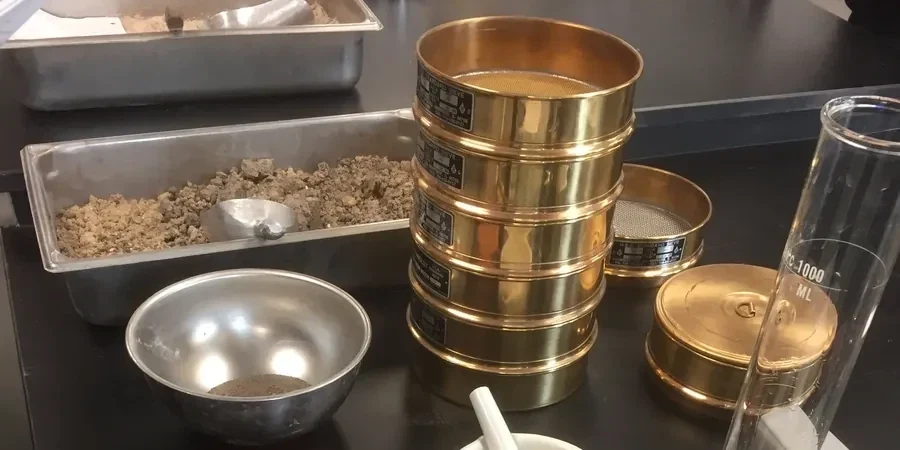
Our services
Every grain size report we deliver for a Visalia project includes the full particle-size distribution curve plotted on a semi-log chart, the D10-D30-D60 coefficients, and the USCS group name with the USDA textural class for landscape and agricultural drainage compliance where needed. Below are the specific testing services we run out of the same soil sample to build a complete geotechnical profile.
Wash Sieve + Hydrometer Package
Combined ASTM D6913 and D7928 on a single split sample. We report percent gravel, sand, silt, and clay, plus Cu and Cc. This is the minimum we recommend for any Visalia site where the USDA soil survey map shows a complex unit like San Joaquin-Exeter association.
Particle-Size Quality Control for Aggregate Base
Targeted sieve analysis on imported Class 2 aggregate base and subbase materials per Caltrans gradation bands. We check compliance against the ¾-inch and ⅜-inch control points and report the sand equivalent value for the minus-No. 4 fraction.
Forensic Gradation on Distressed Pavement Subgrades
When a parking lot or street section in Visalia shows premature cracking, we sample the upper 12 inches of subgrade and run the full curve to identify whether fines migration or a perched water table has altered the design gradation since construction.
Top questions
How much does a grain size analysis cost for a Visalia residential lot?
For a single-sample wash-sieve plus hydrometer package on a typical Visalia residential lot, the fee runs between US$90 and US$160, depending on whether the sample is delivered to our lab or we collect it on site. A multi-depth investigation with four or more samples falls at the lower per-sample end of that range.
Do I need the hydrometer test, or is a simple sieve analysis enough for a house foundation?
If the wash over the No. 200 sieve shows more than 5% fines by mass, we strongly recommend the hydrometer. In Visalia’s San Joaquin and Tulare series soils, it is common to find 15% to 40% silt and clay that the sieves alone cannot separate, and that fraction controls drainage, shrink-swell potential, and the design bearing pressure per IBC Table 1806.2.
How long does it take to get the grain size lab results back?
A standard sieve analysis with hydrometer takes three to four working days from the time the sample arrives at the lab. The hydrometer portion requires a 24-hour sedimentation period, and we run duplicate readings at 1, 2, 5, 15, 30, 60, 250, and 1440 minutes per ASTM D7928. Rush turnaround in 48 hours is possible when the project schedule demands it.
What soil classification system do you report for Visalia building permits?
We report the Unified Soil Classification System (USCS) group symbol and group name per ASTM D2487, which is the language the City of Visalia building department and most geotechnical engineers use. When the project involves landscape drainage or on-site wastewater, we also include the USDA textural class triangle designation on the same report.