ASCE 7-22 and the California Building Code require a site-specific slope stability analysis whenever grading, cut slopes, or natural inclines are within the zone of influence of a proposed structure. In Visalia, this requirement becomes a practical challenge because the city straddles two distinct geologic domains. West of Highway 99, deep Quaternary alluvium forms broad, nearly level fans that mask subtle erosion hazards, while toward the eastern city limit, the terrain begins its transition into the Sierra Nevada foothills underlain by weathered granitic bedrock and older alluvial terrace deposits. Our team has worked on projects from the industrial corridor near Riggin Avenue to residential subdivisions climbing toward Yokohl Valley Road, and we have seen how groundwater perched on clay-rich paleosols can alter the factor of safety more than a simple infinite-slope model would predict. When site conditions warrant, we couple the analysis with in-situ permeability testing to refine pore-pressure assumptions.
A slope that stands at 1.5H:1V in August can lose 40 percent of its calculated factor of safety by February if pore-pressure drainage is not addressed.
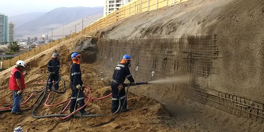
Scope of work in Visalia
Local geotechnical conditions in Visalia
Visalia sits approximately 330 feet above sea level, and while the city itself is not on a steep hillside, the 2023 atmospheric river events demonstrated how quickly local creeks and irrigation canals can saturate embankment slopes that had been stable for decades. The greatest risk we encounter is not a deep rotational failure but a progressive shallow slide triggered by a combination of irrigation overspray, leaking storm drains, and the expansive clay that covers much of Tulare County. A 2019 USGS study on land subsidence in the San Joaquin Valley also documented differential surface strains that can open tension cracks at the crest of older cut slopes, giving water a direct path into the failure plane. We address this by specifying surface-water diversion berms and by running sensitivity analyses that assume fully saturated conditions in the upper 5 feet of the profile, even when borings show dry conditions at the time of investigation.
Our services
Our slope stability work in Visalia is supported by a full geotechnical program that starts with subsurface investigation and ends with construction-phase observation. These are the core services we provide alongside the analysis.
Rotational and Translational Stability Modeling
We build limit-equilibrium models in Slide2 or Slope/W using site-specific stratigraphy, then iterate with both Spencer and Morgenstern-Price methods until we converge on a factor of safety that satisfies the Tulare County grading ordinance.
Shear Strength Testing Program
Triaxial and direct-shear tests on undisturbed samples from the Exeter-Porterville soil series, run at our accredited lab to define the Mohr-Coulomb envelope for each stratigraphic unit.
Groundwater and Seepage Analysis
We install vibrating-wire piezometers for long-term monitoring and run SEEP/W models to calibrate pore-pressure distributions that feed the stability analysis.
Remedial Grading and Reinforcement Design
When the factor of safety falls below code, we design buttress fills, subsurface drains, or soil nail layouts that work with Visalia's alluvial stratigraphy rather than against it.
Top questions
What triggers a mandatory slope stability study under Visalia's building code?
The California Building Code requires a study when a cut or fill slope exceeds 5 feet in height with a gradient steeper than 2H:1V, or when a structure is placed closer than the height of the slope to its crest or toe. We also recommend one for any slope that shows signs of ancient landsliding or that is underlain by the expansive Exeter-Porterville clay association.
How much does a slope stability analysis typically cost for a single-family lot in Visalia?
For a typical residential lot with a 10- to 20-foot cut slope, the analysis ranges from US$1,090 to US$4,380, depending on the number of borings, the laboratory shear-strength program, and whether groundwater monitoring is required over a wet season.
How do you handle the expansive clay that covers much of the Visalia area in a stability model?
We treat the near-surface clay as a material whose strength decays with wetting. We run two scenarios: one using peak strength from dry-season samples and one using fully softened strength after saturation, then we design to the worst-case condition. The residual friction angle for these clays often controls the long-term factor of safety.
Can you perform the analysis without drilling on my property?
We can start with a desktop review of existing USDA soil survey maps and nearby geotechnical reports, but the City of Visalia will not accept a stability analysis without site-specific subsurface data. At minimum, we need a test pit or boring to confirm stratigraphy and collect samples for lab testing.