Visalia sits roughly 15 miles from the Sierra Nevada foothills in California’s Central Valley, a region where deep alluvial deposits shape every construction decision. The 2019 Ridgecrest sequence rattled windows across Tulare County, reminding owners and engineers that seismic risk isn’t confined to the coast. For a commercial building or school project here, determining site class with a MASW / VS30 survey converts guesswork into a defensible design parameter. Our crew runs the survey directly on your parcel — no heavy drilling, no spoils — and delivers a shear wave velocity profile that feeds straight into ASCE 7 ground motion calculations. When soft silts or shallow groundwater complicate interpretation, we often pair the results with a CPT test to verify stratigraphy at depth.
Vs30 is not just a number — it’s the single parameter that can change your seismic design category and structural cost by a full letter grade.
Scope of work in Visalia
Local geotechnical conditions in Visalia
The Central Valley’s alternating drought cycles and flood events create a tricky near-surface environment for seismic measurements. Dry, cracked clay in August attenuates high-frequency Rayleigh waves, while saturated silt in February can mask the fundamental mode. In Visalia, where the water table swings from 10 to 40 feet seasonally, MASW data collected without checking pore pressure conditions can mislead the inversion and shift Vs30 by 15 percent or more. That difference is enough to bump a site from Class D to E, triggering more expensive foundation requirements. We schedule surveys with groundwater conditions in mind and run parallel seismic refraction lines when the velocity contrast is ambiguous. For structures classified as Risk Category III or IV — schools, fire stations, emergency operations centers — the IBC requires site-specific Vs30. Guessing the class from blow counts alone introduces unnecessary liability that no owner should carry.
Our services
Every Visalia project has a different footprint, schedule, and seismic exposure. Our service packages adapt to the specific requirements of your structural engineer and local building official.
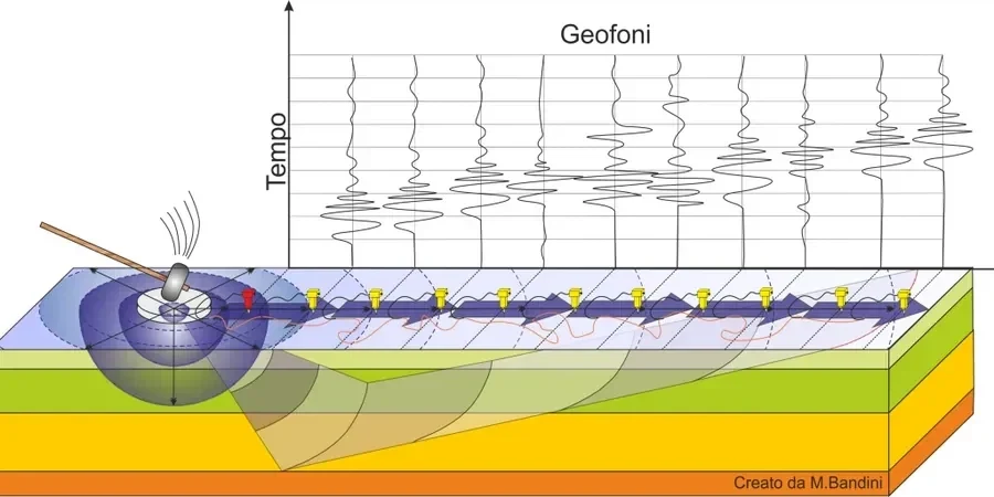
MASW Survey for IBC Site Classification
Full 1D Vs profile with Vs30 calculation and site class letter assignment. Includes raw dispersion data and inversion report signed by our geophysicist.
2D Shear Wave Cross-Section
Multiple MASW arrays stitched into a continuous Vs cross-section, ideal for buildings with elongated footprints or variable subsurface conditions.
Combined MASW + Seismic Refraction
We run refraction alongside the surface wave survey to resolve velocity inversions and map the bedrock surface where it sits within 100 feet.
Liquefaction Screening Using Vs
Vs-based liquefaction assessment per Andrus & Stokoe methodology, correlating shear wave velocity to cyclic resistance ratio for clean and silty sands.
Top questions
What does a MASW survey cost for a single-family home lot in Visalia?
For a typical residential parcel within city limits, the survey runs between US$1,730 and US$3,260 depending on array length, number of lines, and whether we combine it with a shallow refraction profile. We provide a fixed quote after reviewing your parcel size and the structural engineer’s required depth.
Can MASW replace a borehole for site classification?
It can, and often does when the goal is strictly Vs30 and site class. The IBC accepts direct Vs measurement as the preferred method over blow-count correlations. However, if you also need soil samples for bearing capacity or chemical testing, then a borehole or test pit is still necessary.
How long does the field work take, and will it disrupt my site?
A single array takes about an hour to two hours. The equipment is surface-based — a seismograph, a cable spread, and a sledgehammer on a plate. No drilling mud, no cuttings, no heavy trucks. You can walk the site immediately after we coil the cable.
What is the difference between MASW and downhole seismic?
Downhole measures Vs directly in a cased borehole and gives excellent resolution, but it requires a drill rig and borehole access. MASW is non-invasive and averages over a larger volume of soil. Both produce a Vs profile; the choice depends on depth requirements, budget, and whether you already plan to drill.
Does the water table affect MASW results in the Central Valley?
It does, particularly when the saturation front is shallow. Water-saturated fine sands and silts can slow Rayleigh wave velocities and produce a low-velocity layer that complicates inversion. We account for this by measuring the water level on test pits or nearby wells and adjusting the inversion starting model accordingly.